Showing posts with label Google Maps. Show all posts

Travel Back in Time Using Google Earth Historical Imagery Feature.

Google Earth Historical Imagery

Have you ever wished you could see what your neighborhood looked like a decade ago? Or maybe you've been curious to see how a new skyscraper was built from the ground up? While we can't hop into a real-time machine just yet, there's a powerful tool right at your fingertips that can take you back in time: Google Earth's historical imagery feature. It's a digital archive of our planet, captured over years of satellite and aerial photography.

This isn't just a fun gimmick; it’s a portal to the past, revealing dramatic transformations in urban landscapes, the slow march of deforestation, and the powerful impact of natural disasters. In this article, we’ll show you exactly how to unlock this hidden feature and turn your computer into a time machine. Get ready to explore the world not just as it is, but as it once was.

What is Google Earth's Historical Imagery?

Google Earth's Historical Imagery is a feature that allows users to view past satellite and aerial images of a location, essentially creating a digital time-lapse of the planet. Instead of showing just the most current image, it provides a timeline slider that lets you scroll through decades of captured data. It's a powerful tool that reveals how a place has changed over time, from subtle shifts in landscapes to major urban development.

The data for this feature is a massive collection of images from various sources, including satellites like the USGS/NASA Landsat program and high-flying aircraft. Google continuously updates this archive with new imagery, while also organizing older photos. This massive, layered database is what enables you to witness the growth of a forest, the construction of a new highway, or the before-and-after of a natural disaster, all from a single viewpoint.

Google Earth Historical Image of Delhi

How To View Historical Imagery in Google Earth?

The process for viewing historical imagery differs slightly between the desktop application and the web version of Google Earth. For the most comprehensive experience, we recommend using the desktop version.

Let's Go Back in Time With Google Earth 🌍

Method 1: Using Google Earth Pro (Desktop).

Google Earth Pro is a free desktop application that offers the most robust tools, including the full historical imagery timeline.

  1. Download and Open: First, download and install the free Google Earth Pro application from Google's official website if you don't already have it.

  2. Navigate: Search for and fly to the location you want to explore.

  3. Activate Historical Imagery: In the top toolbar, look for the "Show historical imagery" icon. It looks like a clock with a counter-clockwise arrow. Click it.

    Google Earth Pro

  4. Explore the Timeline: A timeline slider will appear in the top-left corner of the viewing window. Drag the slider to the left to go back in time. You will see small white dots on the timeline, each representing a date when imagery is available for that specific location and zoom level. Simply click a dot to see the image from that time.

Note: To save a high-resolution image of what you see, go to File > Save > Save Image. This feature allows you to export the picture with a title, a legend, and a compass, which is perfect for presentations or to show the exact difference.

Method  2: Using Google Earth for Web.

The web version of Google Earth is more streamlined and has a simplified historical imagery feature, which is great for quick looks but isn't as detailed as the desktop app.

  1. Open Google Earth: Go to the Google Earth website in your browser.

  2. Find a Location: Navigate to your area of interest.

  3. Check for Imagery: The web version doesn't have a dedicated clock icon for all locations. Instead, the feature is often found in the "Voyager" tab on the left sidebar, under curated "Timelapse in Google Earth" stories. For some specific locations, a time slider may appear automatically at the bottom of the screen.

    Google Earth Web

  4. Limitations: The historical imagery on the web is not available for all locations, and the timeline isn't as extensive or easy to navigate as the one in the desktop application. For a deep dive into history, the Google Earth Pro desktop app is the superior tool.

The availability of imagery is not uniform across the globe. Some locations, especially older, developed areas, have data going back decades. Other, more remote areas may only have a few years of images. This is because satellite and aerial data collection is not a constant process for every single spot on Earth.

Time lapses in Google Earth.

Google Earth also showcases how our planet has changed since 1984 through its time-lapse feature available in the Historical Imagery section. Unlike the "Historical Imagery" which shows specific photos for a single spot, this tool provides a broader, global overview of change, visually demonstrating everything from urban sprawl and the melting of glaciers to deforestation over the past four decades.

To play a time-lapse video of any place on Google Earth, simply click on View > Historical Imagery, and on the left side, you will see a clock icon (Switch to Time-lapse), and the video will start playing. You can also adjust the zoom and play speed to see a better view.
Google Earth Time-Lapes Video Creation

Conclusion: Your Next Adventure is Just a Click Away.

Google Earth's historical imagery is more than just a cool technical feature; it's a window into the past that allows you to be an armchair historian, urban planner, or environmental scientist. The ability to watch a city rise, a glacier melt, or a forest recover is a powerful reminder of how dynamic our world is. With these tools at your disposal, you're ready to start your own journey through time. 

Now it's your turn. We'd love to hear about the changes you discover. What's the most surprising transformation you've found in your neighborhood or a place you've always wanted to visit? Share your discoveries in the comments below!

Google Maps Update Brings Sleek New M3 Expressive Design.

Google Maps

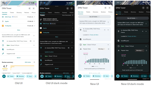
Google is rolling out a new design for its Maps application, featuring an "M3 Expressive" update that introduces a more streamlined and modern interface. This change aims to improve user experience with a focus on consistency and ease of use, particularly for one-handed navigation.

The most notable change is the repositioning of the action carousel for features like Directions, Start, and Ask Gemini. This carousel is now permanently docked at the bottom of the screen, providing a consistent layout. Other changes include a new position for the top tabs (Overview, Reviews, Photos), which are now located above the image previews.

The update also incorporates several visual tweaks to modernize the app's look and feel. The information displayed under the place name, including ratings and distance, has been subtly adjusted. The use of Material 3 Expressive containers replaces the faint line separators in the description and address fields, giving the page a cleaner, more cohesive appearance. Additionally, all buttons have been updated to a pill shape, aligning with Google's broader design language.

This update is currently being seen in the latest beta version of Google Maps, version 25.37.x. The changes reflect a continued effort by Google to refine its most popular apps, ensuring they are both visually appealing and functionally intuitive for the modern user.

Also Read:

Google Maps Introduces "Tap and Hold to React" Emojis for Image Feedback

Google Maps Emojis Reaction

Google Maps is rolling out an exciting new feature allowing users to react to images within business listings using a "tap and hold" gesture to select from a range of emojis. This update, currently in testing for some Android users, aims to boost engagement and provide a quick, intuitive way to offer feedback on the visual content of places.

Similar to how users can react to messages in Google Messages, this new functionality in Google Maps presents a small overlay of five distinct emojis when an image is pressed and held: a heart, praying hands, fire, a side-tongue emoji (likely for food-related reactions), and a mind-blown emoji. While tapping an emoji triggers a small animation, the reactions do not yet appear on the images within the UI, indicating the feature is still under development.

Google Maps Emojis Feedback

This move signifies Google's continued efforts to make its mapping platform more interactive and social. By allowing users to quickly express their sentiments on photos, Google Maps could see increased user participation and richer, more nuanced feedback on places and businesses. While the exact impact on Local Guides and overall listing engagement remains to be seen, this update clearly points towards a future where user reactions play a more prominent role in how businesses are perceived on the platform.

This development is a key indicator of how Google is evolving its core services to foster deeper user engagement and provide more dynamic ways for consumers to interact with local businesses and points of interest. As the feature rolls out more widely, it will be interesting to observe how it influences user behavior and the quality of image feedback on Google Maps.

Google Maps Unveils America's Favorite State Parks of Summer 2025.

America's Favourite State Parks

Hey there, summer explorers! 🌞

Can you believe summer is almost over? But wait—before you pack away the sunscreen and fold up the picnic blankets, have you squeezed in that perfect outdoor escape yet?

If you're still scratching your head about where to go for that final summer getaway, don’t worry—Google Maps has your back!

Google just revealed the most popular state parks in the U.S. this summer, based on location trends and search interest. Whether you want to hike, picnic, or simply relax in nature, Google has compiled data to spotlight the most popular state parks across the U.S. based on how many people asked for directions since Memorial Day 2025. So grab your shades and water bottle—your next adventure might just be a few taps away.

So… where is everyone going?

Most Popular U.S. State Parks This Summer.

Wondering which parks everyone is flocking to this year? Google Maps analyzed millions of searches and shared the parks that have received the most navigation requests. The results are in, and here's the ultimate summer bucket list:

  • Watkins Glen State Park (New York)
  • Liberty State Park (New Jersey)
  • Silver Falls State Park (Oregon)
  • Starved Rock State Park (Illinois)
  • Letchworth State Park (New York)
  • Hammonasset Beach State Park (Connecticut)
  • Point Lobos State Natural Reserve (California)
  • Warren Dunes State Park (Michigan)
  • Blue Spring State Park (Florida)
  • Jones Beach State Park (New York)

So if you’re wondering where the trails are hot (literally and figuratively), these are the places people are heading to the most.

Fan-Favorite Parks for the Perfect Picnic.

If your idea of summer includes a checkered blanket, cold lemonade, and sandwiches under the sun, then you’ll love this. Google also looked at which parks were most mentioned for picnicking in reviews.

Here are the top parks where you’ll find picnic heaven:

  • Liberty State Park (New Jersey)
  • Bear Mountain State Park (New York)
  • Letchworth State Park (New York)
  • Colt State Park (Rhode Island)
  • Lake Sammamish State Park (Washington)
  • Devil’s Lake State Park (Wisconsin)
  • Blue Spring State Park (Florida)
  • Fort Zachary Taylor Historic State Park (Florida)
  • McKinney Falls State Park (Texas)
  • Harkness Memorial State Park (Connecticut)

If you’re planning a family day out or a chill spot with friends, these are great picks to lay down that blanket.

Peak Performer Parks for Hiking Lovers.

Are you someone who thinks of summer as a time to conquer trails and chase sunsets? Google Maps has also revealed which parks hikers love the most, based on the number of reviewers mentioning hiking.

Here are the top hiking destinations that stood out:

  • Devil’s Lake State Park (Wisconsin)
  • Starved Rock State Park (Illinois)
  • Palo Duro Canyon State Park (Texas)
  • Watkins Glen State Park (New York)
  • Valley of Fire State Park (Nevada)
  • Turkey Run State Park (Indiana)
  • Bear Mountain State Park (New York)
  • Letchworth State Park (New York)
  • Cloudland Canyon State Park (Georgia)
  • Smith Rock State Park (Oregon)

From waterfalls to canyons, these parks deliver the wow-factor for your hiking boots.

This data isn't just a guess, Google Maps analyzed the number of direction requests and review mentions from Memorial Day 2025 onward to spotlight which parks Americans are loving this summer. These insights can help you pick a destination based on what real people are actually searching for, not just marketing hype.

So, what are you waiting for?

There’s still time to make this summer unforgettable. Grab your water bottle, lace up those hiking boots, and let Google Maps guide you to your next outdoor escape. 🍃

Google Maps Crashes on Android When Searching Transit Directions.

Google Maps Open on Android Phone
Key Takeaway.
  • Google Maps is crashing when users request public transit directions on Android, while other navigation types still work.
  • Clearing the cache and rolling back app updates may offer temporary relief until Google releases a fix.

Some Android users are reporting that Google Maps crashes whenever they attempt to get public transit directions, such as buses or trains. Walking, driving, and cycling directions continue to work as expected. The problem has been noted across different devices and regions, including the U.S., the UK, Germany, and others.

Users on Reddit and Google’s support forums have shared frustrations that clearing the app cache, reinstalling Maps, and even wiping app data did not resolve the issue. The crash consistently occurs immediately after selecting public transport directions.

Also Read: Google Confirms Media Controls Bug in Google Maps.

Android Authority and Android Police have independently confirmed the crash in recent versions of Google Maps—especially version 25.30.00.785163646—even though not every user on that version encounters the problem. The inconsistent impact suggests the bug may be tied to specific device configurations or account setups.

At this point, Google has not issued an official response or announcement. The Maps status dashboard remains unchanged, indicating that the issue may not yet meet the threshold for a public incident report.

Affected by Google Maps Crash.

Public transit navigation is the only category causing crashes. Users reported that stops, routes, and schedules related to buses or trains trigger the app to abruptly close. All other navigation modes continue to function normally.

Affected users can consider temporary workarounds:

  • Try using driving or walking directions instead of transit
  • Switch to another navigation app for public transport, such as Moovit or Citymapper
  • On Android, uninstalling recent updates may help restore functionality—via Settings → Apps → Google Maps → tap overflow menu → Uninstall updates.

Google appears to be aware of the issue based on rising community reports and public threads. An official fix may already be in development. Users should keep Google Maps updated and check for new releases in the coming days.

If the issue continues, you might also consider reaching out to Google support or sharing your experience via Google Maps’ feedback tool.

Google Confirms Media Controls Bug in Google Maps: Fix on the Way

Google Maps Logo on a Phone

Google Maps on Android recently experienced an unexpected glitch that removed the integrated media playback controls for music apps like YouTube Music and Spotify. Users on version 25.28 (stable) and 25.29 (beta) noticed the absence of album art, play/pause, skip buttons, and the “Show media playback controls” toggle under Settings → Navigation—a feature that remains fully functional on iOS devices.

Key Takeaway.
  • Google Maps’ built-in media controls for Android were unexpectedly removed in recent updates, and users can’t access playback without switching apps.
  • Google has confirmed the issue is a bug and said it is actively working on restoring the media controls in an upcoming update.
Google Maps Media Playback Settings
Media Playback Control in Google  Maps

These media controls once appeared as a convenient bottom bar during navigation. They displayed album art, song titles, artist information, and offered quick access to the default media app. Drivers could skip tracks, pause, or tap “Browse” to get nine song suggestions and all without leaving the navigation screen.

While some users suspected Google removed the feature intentionally during the transition away from Assistant Driving Mode, the company clarified that the disappearance was due to a bug. A spokesperson confirmed that Google is “actively working to fix an issue that is affecting media playback controls on Google Maps,” although an exact timeline for the fix has not been shared.

For now, Android users must rely on alternative methods for media control, such as notifications or launching their music app directly. Some are even exploring navigation alternatives like Waze, which still supports in-app media controls. Meanwhile, Google reassures users that the feature is not going away permanently but will return in a future update.

Google Maps Testing UI Revamp for Place Listing Pages on Android.

Google Map Open on a Phone
Key Takeaway.
  • Google Maps is testing a refreshed UI for place listings, featuring a cleaner Material 3 card layout and improved readability.
  • Key changes include moving “Popular Times” above reviews and turning core actions like “Suggest an edit” into prominent buttons.

Google Maps is receiving a subtle but impactful redesign of its place listing pages on Android, using an updated look to improve clarity and usability. These changes are currently spotted in version 25.29.00.782600971 via an APK teardown from Android Authority.

First and foremost, the overall visual design moves to a cleaner, Material 3-style card interface, replacing the earlier line-separated layout. This refresh enhances readability and aligns Maps with Google's evolving design language.

Another notable update involves the reordering of the “Popular times” section, which previously appeared below user reviews but now sits above them. This means users can more quickly assess peak visitation data before diving into reviews.

Credit: Android Authority

Google has also improved the layout for interactive tools: Suggest an edit, measure distance, add a missing place, and add your business. These are now fully furnished buttons rather than tucked-away options. These buttons are more prominent, particularly when viewing information about broader areas like cities or countries.

Why This Update Matters

This more refined interface ensures that essential details like visitation peaks and useful actions are immediately visible, making the app faster and more intuitive. Whether you're planning a trip, exploring a new city, or checking business hours, the updated placement and clarity of these elements make key information quicker to access while keeping the map context front and center.

What’s Next?

As this redesign is currently in the early testing phase, users may see the changes roll out gradually through upcoming updates. If the new design gains positive feedback, it could become the standard interface for Google Maps place listings on Android devices worldwide.

Google Maps Removes Media Playback Controls in Android.

Google Maps Logo on a Phone Screen
Key Takeaway
  • Google Maps has removed in-app media playback controls on Android, frustrating users who relied on them during navigation.
  • The change follows the shutdown of Assistant Driving Mode, while iOS users still retain the media control feature.

Google has recently removed a much-loved feature from its Android Maps app: media playback controls for platforms like Spotify and YouTube Music. Originally introduced after the discontinuation of Assistant Driving Mode, this feature allowed users to access play, pause, skip, and browse functions directly within the navigation interface via a compact bottom sheet.

Latest Update: Google Confirms Media Controls Bug in Google Maps: Fix on the Way. 

Users could view album art, track names, and artist info at a glance, and switch tracks without leaving Maps. A dedicated “Browse” button provided quick access to song suggestions, while a persistent shortcut to open their default music app made the experience seamless. However, this also partially obscured the “Report” button beneath it, though the underlying functionality remained accessible.

As of versions 25.28 (stable) and the newer 25.29 beta, Android users have noticed that the “Show media playback controls” toggle under Settings → Navigation has vanished. The prior “Default media app” option is also gone. It's unclear whether this disappearance is intentional or an oversight, but it starkly contrasts with iOS, where the toggle remains intact.

Google Maps Playback

Community reports suggest this removal is frustrating for many users, particularly those using non-default audio apps. On forums like Google's own support thread and third-party sites, users report a fragmented experience—where third-party media control support had already been inconsistent—and express hope for Google's reconsideration.

Why It Matters

This change highlights a broader trend driven by Google’s transition from Assistant Driving Mode to the Gemini ecosystem. In February 2024, Google officially shuttered Assistant Driving Mode after gradually stripping away its features; by April 2025, media and voice controls were entirely removed from Maps. Without proper in‑app media controls, users now find themselves repeatedly switching between Maps and their music apps—a disruption from the fluid, hands‑free experience that once existed.

With in‑map media access disappearing, users have grown more vocal about the need for seamless integrations, especially when driving, where safety and convenience are paramount. Google has yet to comment on whether this media toggle removal is a bug or a permanent design shift.

What’s Next?

For now, Android users relying on Spotify or other music services during navigation must manually open their apps to control playback. If the toggle removal is unintended, it could soon return in an upcoming update, given the strong user backlash and safety implications. Meanwhile, iOS users will continue enjoying the feature uninterrupted.

DON'T MISS

AI
© all rights reserved
made with by WorkWithG